

Gravel Routes For All Abilities
Starting and finishing in the centre of Aberfoyle village we have 3 way-marked routes that explore deep into Loch Ard forest
SHARED USE TRAILS
Our popular waymarked trails are all shared with different user groups and we emphasise the importance of courteous and responsible behaviour whilst you are out and about in ‘Gravelfoyle’. You are likely to come across hikers, dog walkers, other cyclists, horse riders, Duke of Edinburgh groups and parents with children on our waymarked loops. For more information see our ‘Trail News’ Page.
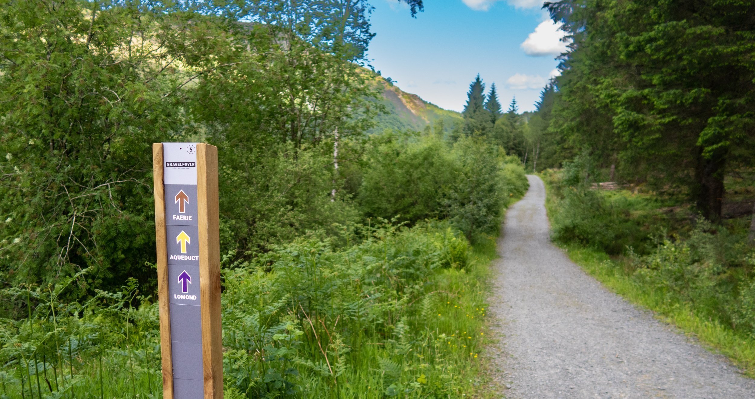
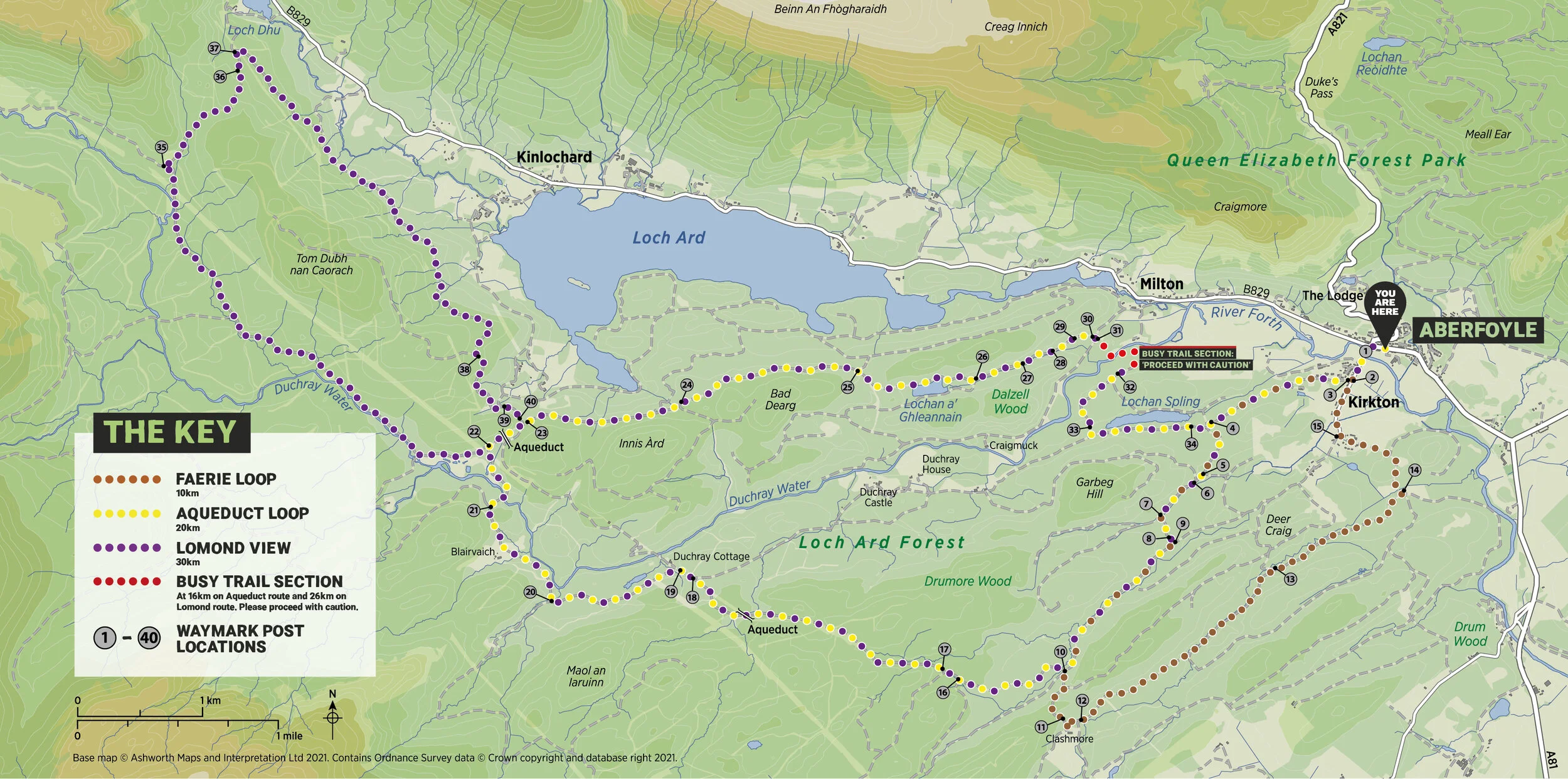
Route Information - Map available here.

Faerie Loop
Ideal for: Active families and beginners
Distance: 10km
Estimated time: 1 to 1.5 hours
Elevation gain: 164m
Hardest climb: 2km, 2.5% average with <100m at 10%
Gravel Terrain:
Tarmac - 1.1km
Fine - 9.1km
A fantastic undulating ride through the southside of Queen Elizabeth Forest. Gradually winding through the forest where sightings of red squirrels, badgers and deer are not uncommon. The route returns into Aberfoyle past Doon Hill which is home to the renowned ‘Faerie Tree’ that sits right at the summit and just a short hike from the trail.
The route follows 100% wide forest roads with some gentle slopes. There are a variety of surfaces, potholes, bridges without handrails and in wet conditions some stretches can be damp. Mid-way there is a long but gentle climb of 500m distance.
GPX link here

Aqueduct Loop
Ideal for: E-bike exploring and recreational cyclists
Distance: 20km
Estimated time: 1.5 to 2 hours.
Elevation gain: 294m
Hardest climb: 3km, 4% average, with <50m at 9%
Gravel Terrain:
Smooth Tarmac - 0.8km
Fine - 14km
Medium Coarse - 2.4km
Coarse - 200m pave
Espresso Singletrack - 2km
A stunning, challenging ride taking in some of the Trossachs’ most incredible views. The trail heads west of Aberfoyle taking riders deep into the forest discovering wonderful feats of Victorian engineering. The return delivers beautiful panoramic views of Loch Ard. Keep an eye out for a wide range of wildlife along the way.
The route is mixture of wide forest roads combined with some short sections of narrow singletrack. Surfaces range from smooth gravel to some rougher sections with potholes. There are some moderate climbs of up to 500m in length. Watch out for traffic and a busy section of trail around Milton Public Car Park at 16km distance.
GPX link here

Lomond View
Ideal for: More experienced cyclists and E-bikers
Distance: 30km
Estimated time: 1.5 to 2.5 hours
Elevation gain: 494m
Hardest climb: 1km, 6% average with < 50m at 12%
Gravel Terrain:
Smooth Tarmac - 0.8km
Fine - 22.2km
Medium - 1km
Medium Coarse - 2.4km
Coarse - 200m + 300m pave
Espresso Single-track - 2km
An extension of the Aqueduct Loop this delivers riders a longer route and rewards them with breath-taking views of Ben Lomond and Loch Ard. Head towards Ben Lomond through some wild expanses before turning back towards Loch Ard and an exhilarating ride along the old ‘Statute Labour Road.’
The route combines a mixture of wide forest roads with some short sections of narrow singletrack. There are some steep climbs of up to 1km along with a variety of gravel surfaces from smooth gravel to some rougher, loose sections with potholes. Watch out for traffic and a busy section of trail around Milton Public Car Park at 26km distance.
GPX link here